Your browser version is outdated. We recommend that you update your browser to the latest version.

Airport

$1.2 Million construction project in 2015 to include:

    - New Taxiway

    - Apron and Helipad improvements

Funding provided by: FAA, Oregon Lottery, and the Park and Recreation District.


| Airport Map | Airport Data | Declared Distances | Runway Data |


Christmas Valley Airport Fee Schedule

Runway Access/Egress (per year) - $300
Tie down on Tarmac (per month) - $25

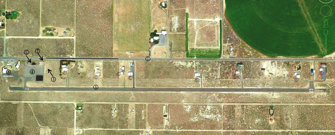
Airport Map (see below)
Legend

  1. Runway 7-25 : 5200' x 60'
  2. Christmas Valley Highway
  3. Segmented Circle
  4. Aircraft Apron
  5. Automobile Parking
  6. Aircraft Hangars
  7. Aircraft Beacon
  8. FBO/Fuel (NO LONGER AVAILABLE)


Airport Data

EXISTING
FUTURE
Airport Elevation
4317.0'
SAME
Datum for all items
NAD 83/NOVD 29
SAME
Airport Reference Point Coordinates (ARP)
LAT N 43* 14' 12"
LONG W 120* 39' 58"
SAME
Airport Magnetic Deviation
18* E
SAME
Mean Maximum Temperature
80* F
SAME
NPIAS Role
CA
CA
Airport Reference Code

B-1 (SMALL)

B-1 (SMALL)
Airport Code
62-S
SAME
Land Owned in FFE (Acres)
68
SAME


Declared Distances


Runway 7
Runway 25
 
EXISTING
FUTURE
EXISTING
FUTURE
Takeoff Run Available (TORA)
5200'
5200'
5200'
5200'
Takeoff Distance Available (TODA)
5200'
5200'
5200'
5200'
Accelerate - Stop Distance (ASDA)
5200'
5200'
5200'
5200'
Landing Distance Available (LDA)
5200'
5200'
5200'
5200'


Runway (7 and 25) Data

 
EXISTING
FUTURE
Length and Width
5200' x 60'
SAME
Percent Effective Gradient
0.1%
SAME
Percent Wind Coverage (12 mph)
97.7 % All Weather
SAME
Pavement Type
Asphalt with BST
SAME
Pavement Strength
12,500 S.W. (est) *See Note 1
SAME
Approach Type
Visual *See Note 2
SAME
FAR PART 77 Designation
Utility
SAME
Approach Slope Req'd Clearance - Runway 7
20:1
SAME
Approach Slope Req'd Clearance - Runway 25
20:1
SAME
Runway Lighting
MIRL
SAME
Runway Marking
Basic
SAME
Runway Safety Area
5680' x 120'
SAME
Object Free Area
5680' x 250' *See Note 3
SAME
Obstacle Free Zone
5600' x 250'
SAME
Critical Aircraft
BE - 58
BE - 58
Navigational Aids
None
GPS *See Note 2
Approach and Landing Aids Runway 7
None
PAPI
Approach and Landing Aids Runway 25
None
PAPI
Runway End Coordinates Runway 7
LAT N 43* 14' 10"
LONG W 120* 40' 28" (est)
SAME
Runway End Coordinates Runway 25
LAT N 43* 14' 10"
LONG W 120* 39' 16"(est)
SAME
Taxi Lighting
None
Reflectors/MITL